
 |
 |
|
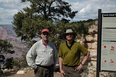
Sunday at 2pm, I reached the South Kaibab trailhead ending a five-night trip to Clear Creek with hiking buddy, Dennis Foster. The trip began late Tuesday morning with our first steps down the Bright Angel trail. After a lunch break and water refill at Indian Garden, we headed east on the Tonto trail to pick up the route to the Old Bright Angel trail.
Old Bright Angel runs with the telephone poles through the drainage immediately east of Garden Creek. The route to this well-preserved trail exits the Tonto atop a ridge just east of Garden Creek, switchbacks into the drainage and runs along the east slope until a junction with the contemporary Bright Angel trail near the top of Devil's Corkscrew. Arriving at Phantom Ranch about 5:30pm, we selected a campsite, made dinner and bedded down for the night.
After a night of fitful sleeping due to intermittent rain--it rained every night except Friday--we ate breakfast while waiting for the early morning Sun to dry our tents. It was 9:40am when we began the trek to the Clear Creek trailhead. We reached the turnoff by 10:00am, the cairns at the border of the Clear Creek use area shortly after noon and quickly settled into a good rhythm hiking along the Tonto.
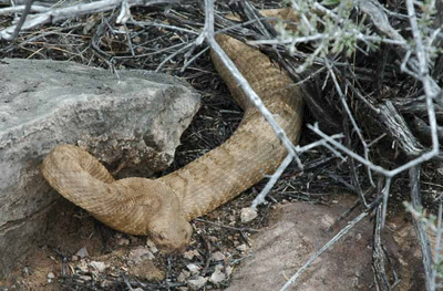
Soon after crossing the Zoroaster drainage, I was stopped in my tracks by the unmistakable buzz of a Grand Canyon rattlesnake. He was shading beneath a trailside bush when we happened along. We got a few pics before continuing down trail. The remainder of the day was reasonably tame by comparison. We took a late lunch in a drainage off Demaray Point, stopped for the occasional photo op--including a pic of Angels Gate (aka Snoopy Rock)--paused to admire our first view of Clear Creek, descended through the Tapeats and arrived at the campsite at 5:30pm.
While Dennis has camped more than 250 nights in Grand Canyon, this was my second Grand Canyon backpack and first trip to Clear Creek. It's a beautiful location with many fine, shaded campsites. The filtered creek water tastes cool and sweet. About the only negative is the NPS-provided toilet. There are two ways to describe that facility. The polite way would be to say it was unusable. The unvarnished truth is that the thing was infested with maggots. But that was a minor distraction. We weren't there for the facilities; we were there to enjoy a beautiful area of the canyon.
Thursday, we left at 11:00 am for a day trip upstream to find a cave explored by Harvey Butchart. At noon while hiking across the terrace just below the Gila Pueblo ruins site, we happened upon what appeared to be an ancient agave roasting pit. We explored that for a bit before hiking up to the ruins. After an hour at Gila Pueblo, including time spent reading past entries in and adding our entries to the log book, we headed north along a creek running through a canyon fed by branches off Ariel Point and Francois Matthes Point. This is opposite the northeast branch of Clear Creek that leads to Cheyava Falls. We'd decided to bypass Cheyava after a quick visit to Mather Point, Tuesday morning, had confirmed it was still running dry.
Both Dennis and I had read in Butchart's logs of a cave that can be approached from the north canyon. We hiked up-canyon to the junction of the Francois Matthes and Ariel branches. Taking the left branch and heading northwest toward Ariel Point, we enjoyed a late lunch along the creek before continuing upstream to find the approach route to Butchart's cave. We spotted the cave about 3:30 pm, identified the approach, dropped most of our gear and began the ascent to the base of the Tapeats. About an hour later, we were standing at the base of the Tapeats. The routes upward to the level that would allow access to the cave were more challenging than either of us was willing to accept at that late hour, so we took a few shots looking toward Francois Matthes Point before descending to collect our gear cache for the hike back to camp.
A soft drizzle started as we were making dinner and, as darkness fell over the canyon, the first of a group of nine hikers arrived at Clear Creek. (We later found out they were a bachelor party. Now, there's a fresh twist on an old tradition!) It had been raining steadily for over an hour when the last member of this party arrived, soaked to the bone. If any member of that party happens to read this report, please pass along my congratulations to the groom.
The rain continued most of the night and into Friday morning. A steady light rain was still coming down at noon, but I was beset with "cabin fever" and decided to head out for a short day hike to explore the canyon running east from Clear Creak. After two days of dealing with nearly constant soreness, I was finally beginning to feel my canyon legs. My calf and thigh muscles had become used to the up & down routine of hiking in the canyon and no longer complained at any significant change in slope. Even the weather contributed to my enjoyment of the hike; misty clouds shrouding the surrounding buttes and temples, giving them an aura of mystery.
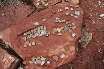
While following a trail across a terrace adjacent to Clear Creek, I found myself walking through the middle of an agave roasting pit. Recalling that we'd found a similar pit in the vicinity of Gila Pueblo the day before, I decided to explore a bit. Well, you can imagine my surprise when I found a fairly good-sized ruin. This is a multi-room complex that, from all appearances, has not been visited by anyone in the recent past. One of the rooms features a circular stone wall with stone flooring and a bench. And scattered across the floor, were hundreds of pottery sherds.
It was at this point that I cursed myself for not having my camera. But I was also excited and wanted to share my discovery with someone so, it was back to the camp to get Dennis. We returned with our cameras and took several shots to document the site. Dennis suspects the circular room may be an ancient kiva or ceremonial room. After further exploration of the area, we returned to our camp. By mid-afternoon, the rain had stopped which made for a pleasant evening as we made dinner and began packing for the return hike to Phantom Ranch in the morning.*
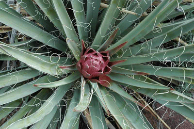
Friday night was our only dry night of the trip and, Saturday morning, we broke camp relatively early. We were on the trail by 8:30 am and made good time to Phantom Ranch, arriving at the cantina at 1:20 pm. Along the way, we enjoyed views of a desert awakened by spring rains. We saw agave shoots straining to reach the sky, Indian Paintbrush blooming a vibrant red and cactus buds preparing to bloom. I imagine anyone hiking the Tonto in the next few days will be treated to a scene of a desert full of life and color.
After making reservations for the 5:30 am Sunday breakfast, we chose a site along Bright Angel creek and setup camp. The rain clouds had mostly cleared, which allowed our tents to dry in the afternoon Sun. A bit later, we trundled back to the cantina for a cold beer. My goodness that hit the spot! Following dinner, I walked over to the evening ranger talk. The program was on cougars and was quite entertaining. Leo rising over the canyon walls provided an appropriate backdrop to her presentation.
Sunday's breakfast was the first full meal I'd had in nearly a week. So, fueled by pancakes, bacon, eggs, peaches and coffee, we set off on our hike to the South Rim. Dennis wanted to take the Old Miner's route from the river to the Tonto and it didn't take much arm-twisting to convince me to tag along. We crossed the Silver Bridge and headed west along the River Trail to the first major drainage. There, we began an ascent through the Vishnu Schist. It was 8:15 am.
The first 20 feet or so is a pure rock scramble, but the rest of the route is well-preserved and fairly easy to follow. This was the path to the river east of Bright Angel before the South Kaibab was built. After 30 minutes of climbing, we reached an overlook offering fine views of the river bridges and across Granite Gorge to Sumner Butte and Buddha Temple. We rested here a bit before continuing up through the Tapeats. We reached the Tonto at 10:00 am and took some photos standing next to the large rock cairn marking the route's location. Then, it was off to find the Tonto trail and make the short hike east to the intersection with South Kaibab.
After a much-needed rest, it was off on our first leg of the hike up South Kaibab: the climb to Skeleton Point. It took about 45 minutes to hike from the South Kaibab/Tonto junction to Skeleton Point and, by then, I was ready for a snack and some water. We rested on a shelf and watched a mule pack train pass while recharging the internal batteries. Gookinaid is amazing stuff. I always feel stronger after a half-liter. The next leg took us up to Cedar Ridge. We left Skeleton Point about 12:15 pm and arrived at the Cedar Ridge rest are some 50 minutes later. While finishing the last of my trail mix and quaffing another half-liter of Gookinaid, two California Condors soared up and directly overhead. I grabbed my camera and managed to get a quick shot of one before it departed to the northeast. Condors are magnificent birds.
We started the final push from Cedar Ridge to rim at 1:40 pm and reached the trailhead 50 minutes later. It was a great trip with so many lasting memories: hiking the old routes, trekking across the Tonto, encountering a rattlesnake, exploring ancient Anasazi ruins. I can't wait for my next Grand Canyon backpack. That's coming up in mid-May, when I've got a permit to hike the Hermit/Tonto/Bright Angel loop.
Bill Ferris
Flagstaff, Arizona
Note: Soon after returning home from this trip, I contacted the Grand Canyon National Park staff to report the ruins I found and am awaiting their reply. If you'd like to read Dennis' account of our trip and view his photographs, please visit the Hiking Grand Canyon section of his Kaibab Journal website.
 |
 |
 |