
 |
 |
|
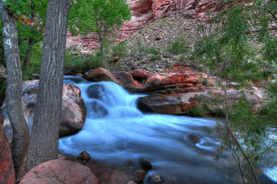
The Thunder River-Deer Creek loop is iconic among Grand Canyon hikes and for good reason. It exposes a person to the full range of Canyon landscapes, including long-strided strolls across the Esplanade, the rolling terrain of Tonto level hiking and lush riparian areas around water-rich oases. The abundance of water makes this one of the few Grand Canyon hikes where one can travel from one camp to the next confident of never being more than a few minutes from this essential resource. And of course, no hike in this great chasm could be considered iconic without offering a wealth of spectacular views. The Thunder River-Deer Creek loop offers a host of grand vistas.
This is also a hike that requires significant investment in time and planning. The traditional starting points for the Thunder River-Deer Creek loop are the Thunder River trailhead at Indian Hollow and the Bill Hall trailhead at Monument Point. I chose to enter the Canyon via Bill Hall, which would remove about six miles of trail on both ends of the hike. The Bill Hall trailhead is located on the north rim and is accessed via an assortment of well-maintained forest roads. It's a three-hour drive from Flagstaff to Jacob Lake Inn. From the inn, it's another hour to Bill Hall along 35 miles of forest roads. I arrived late in the afternoon on the Tuesday before my hike. The plan was to spend the night at the trailhead so I could get an early start in the morning.
About an hour after I arrived, a truck carrying three guys from Tennessee pulled into the parking area. They were on a whirlwind tour of the Southwest, having started the day hiking a 14'er in Colorado before heading south into Arizona for their Grand Canyon hike. The four of us walked a short way down trail to the Bill Hall memorial. The skies were gray and threatening. It had been raining on and off for the last three days. While the weather forecast called for clearing skies later in the week, the early autumn rains were expected to continue at least through the following day. The moody skies provided a dramatic setting for some HDR sets.
The Tennessee guys had a notion to do some hiking and camp on the Esplanade for the night. By contrast, I was glad to be eating a bag of Mountain House sweet & sour pork in the cozy confines of my Isuzu Rodeo. By the time they ambled out of the parking area, the sun had set and it was fully dark. Their headlamps bobbed up and down ever so slightly as they walked along. The occasional lightning strike lit up the night. Rain pelted my windshield with each passing squall. Outside, conditions were brewing an angry night to be hiking in Grand Canyon. Inside the Rodeo, I was dry and comfortable in my 15 degree bag. I fell asleep about 8:30 pm.
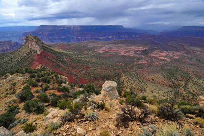
The following morning, a steady drizzle stayed with me from the time I left the parking area until I rounded Monument Point. It was still early when the rains first abated. I had been on the trail less than an hour. The Bill Hall trail descends through 1,700 feet of stone over a distance of about three miles until reaching its junction with the Thunder River trail on the Esplanade. While making my way along the Toroweap traverse, the views alternated between spectacular and somber. At times, brooding clouds encased much of the Canyon. But when the clouds eased off, dramatic vistas emerged.
Off to the west, mist churned off Fishtail Mesa much as smoke erupts from a fire. Bridgers Knoll anchored the view to the south with Great Thumb Mesa seen across the river in the distance. Lightning strikes peppered the horizon sending thunderous echoes throughout the great gorge. But the predominant feature in this area of Grand Canyon is the Esplanade. Extending from Monument Point to Fishtail Mesa, the Esplanade covers an expanse of perhaps 20 square miles. It is to Grand Canyon what the Great Plains are to North America. Rather than a sea of tall grass waving in the wind, the Esplanade is a sea of stone; stone that has been sculpted by water over the ages. Just as the Great Plains are emblematic of the fertility of the soils blanketing this continent, the Esplanade is the visible evidence that water, more than any other force, has shaped Grand Canyon.
I cached a 20 ounce bottle of water on the gentle slopes below the Coconino sandstone. The water would come in handy on the hike out, five days hence. This was the second of three water caches I made. The first was at Monument Point where the trail begins its descent through the Kaibab formation. The next and last would be at the edge of the Esplanade near the Surprise Valley route. Over the next hour and a half, I made the 2 1/2 mile stroll across the wide open expanse of the Esplanade. The trail was well-defined by years of use and the occasional cairn served to confirm being on the correct route.
Upon reaching the descent route off the Esplanade, I took a short break to allow a downpour to pass. When the skies cleared, I walked to the edge of the Esplanade and beheld Surprise Valley. It looked lush and green, not at all like the kind of place where a person could die. Sadly, just such a tragedy had occurred in July 2009. Bryce Gillies, a 20-year-old student at Northern Arizona University, had begun a backpacking trip from Monument Point late in the afternoon on July 18, 2009, the hottest day of the year. If he left the parking area at 3:00 pm, Gillies would have followed the Bill Hall trail to the Esplanade, a trek that takes two to three hours. Rangers involved in the search for Gillies, later speculated that he may have spent the night camped at one of the many available sites on the Esplanade. It's also possible that the young engineering student continued hiking, following the well-worn path across the Esplanade and then the switchbacking descent down into Surprise Valley.
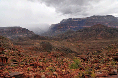
Whether he arrived in Surprise Valley late on July 18 or in the morning on the following day, Gillies would have followed the Thunder River trail into Bonita Creek drainage. At that point, he would have been less than 30 minutes from an overlook offering an awe-inspiring view of Thunder River. Thunder River literally gushes from the vertical face of the Redwall and follows a tumultuous half-mile path to its junction with Tapeats Creek. Water doesn't come any more pure than Thunder River. It can be drunk without filtering or treating and, according to some, is the best-tasting water in Grand Canyon. But for some reason, Gillies did not follow the trail to Thunder River. Instead, he diverted his path and followed Bonita Creek. Perhaps, he was in search of water. The heat and dehydration may have combined to influence his decision to abandon the established trail. Heat exhaustion can have that effect, impairing one's judgment and leading a person to compound the consequences of a single bad decision through later bad decisions.
For whatever reason, Bryce Gillies committed himself to following Bonita Creek all the way to the Colorado River. He downclimbed several pouroffs en route to the river. Eventually, he somehow negotiated a two-story pouroff. At the bottom, he would have found himself facing another even more precipitous spill. Vertical walls on either side and the steep obstacle he had just overcome would have prevented him from exiting the drainage or backtracking to Surprise Valley. It was there that Gillies' hike ended, there that his lifeless body was found by search and rescue rangers.
At 11:36 am on October 6, 2010 I entered Bonita Creek and stopped to listen for the sound--even a hint--of Thunder River. Nothing. Looking around, the creek bed offered little in the way of encouragement that water would be found by following this rocky route. But the trail offered hope. It confirmed that countless hikers had passed this way over the years, had followed this path and found water. Sustained by that knowledge, I continued on my way.
About twenty minutes later, I crested a ridge and saw the great gushing torrent of Thunder River. I remained in its presence for the next 90 minutes, stopping at vantage points to photograph the stream pouring from the red-stained limestone wall, taking a spur trail to the very base of the thing where I ate my sandwich while serenaded by the drum roar of tons of water pounding rocks, and then shadowing Thunder River's tumbling path all the way to Tapeats Creek. Thunder River almost defies description. The main stream bursts forth from stone, seeming to leap with great enthusiasm into the canyon. This stream smashes into stone shelves below and is barely slowed in its violent progression. The torrent races along the base of the canyon, its water as white as white gets...a pure white, an intense blinding light of white. It froths and churns like a thing struggling for freedom from the confines of its gorge.
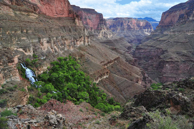
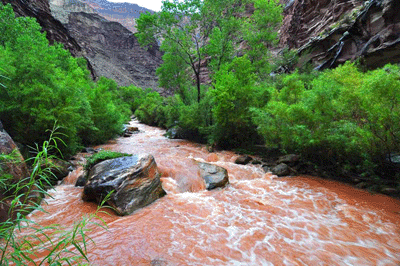
Ultimately, the contents of Thunder River empty into Tapeats Creek, joining with that flow and continuing south to join forces with the Colorado. It was the middle of the afternoon when I arrived at the designated upper Tapeats campsite, took off my pack and began setting up camp. There was one final downpour on this day. And in its aftermath, Tapeats Creek was transformed from a clear-flowing stream to a muddy mess. Later that night while making the final entry in my hiking log, I mulled the options for the next day. I could hike up to Tapeats Cave as planned or explore the trail to the river scouting for a place to cross Tapeats Creek. That was a decision that could be left to the following morning.
For my layover day at upper Tapeats, I chose to day hike to the Colorado. The next day I would need to cross Tapeats to reach the trail to Stone Creek. Tapeats Creek is not to be trifled with. Other than the Colorado and Bright Angel Creek, Tapeats may have the strongest flow of any creek I've seen in Grand Canyon. So, leaving camp that morning, I followed the trail along the west side downstream, always keeping an eye on the creek looking for a crossing. Not too long after leaving camp, I spotted a group of six to eight people hiking upstream along the east side trail. A woman in that group spotted me and we exchanged waves of good morning. The roar of the water made a verbal exchange impossible.
Soon after, I arrived at the first bypass. There are four places along this trail where an obstacle forces the route high above the creek. The first two are relatively minor up-and-downs that offer little challenge. Coming down off the second, I saw a great blue heron take off from the opposite side of Tapeats Creek and fly upstream. This large bird displayed incredible grace and ease in its flight. The third bypass climbed quite high and stayed there for a good distance. The descent back to creek level was steep and a bit scrambly. But once back at the creek level, I was treated to something special. It was a waterfall.
Dennis Foster had prepared some notes on this section of the trail and given them to me at lunch the week before the hike. The notes were taken from George Steck's and Harvey Butchart's writings. Steck's notes included a reference to a fall where he had stopped for lunch, a place he called a "Mini Niagara." Steck's mini Niagara was plainly visible just upstream from where the west side trail returns to Tapeats Creek. I stopped to take some photos and then continued on my way.
A short distance downstream from the mini Niagara is the place where the trail begins its bypass of the lower narrows. The trail follows a bench that angles up to a point overlooking the Colorado River at the mouth of Tapeats Creek. The foot of the bench is also where hikers cross to get to the east side trail. It's not the only crossing but, of all the candidates I saw on this hike, this one appeared to offer the least risk. Once across to the east side of the creek, there is a trail along a corresponding bench that can be followed to the mouth, around and upstream along the Colorado to Stone Creek. From my vantage point on the opposite bench, the east side route was obvious.
Later that night back at camp, I used my 10x20 mini-binoculars to do a little stargazing. The Summer Triangle stars of Deneb, Vega and Altair were high overhead. I followed a line from Deneb past Vega to the keystone asterism in Hercules and found the globular star cluster, M13. I also observed the Andromeda Galaxy (M31), the Coathanger star cluster (Cr 399) and several celestial gems in Sagittarius. These included the stunning globular cluster, M22, near the top of the tea kettle asterism, the Lagoon Nebula (M8), the Trifid Nebula (M20), the Milky Way Star Cloud (M24) and the Swan Nebula (M17). All were found from memory, which is quite surprising when you consider it's been several years since I regularly did any astronomical observing. It was fun to shake some of the rust off.
The lower falls in Stone Creek are amazing! Every bit of 20-feet tall, its cool and clear water splashes to the pebbly creek bed below and then traces a meandering path over a distance of about 200 meters to the Colorado River. When I arrived at the falls early on the afternoon of my third day, the first thing I did was stand under the falls for several minutes. It felt incredibly refreshing. Emerging soaked to the skin, I laid my clothes across boulders to dry in the sun and then returned for a second dousing beneath the falls. It was heavenly. And all this little piece of paradise cost was a small tube of chapstick.
Earlier that day, I had left camp at 8:20 am and, just twenty minutes into the hike, stopped to replace my wide brim hat with a bandana. The gear exchange only took a few moments and then I was back on the trail. Coming down off the first bypass, I met one of the three guys who had pulled into upper Tapeats the previous afternoon. We stopped for a brief chat, before continuing on our respective ways. Although I was fully prepared to make the trek along the west side trail to the crossing below the mini Niagara, I was still keeping an eye open for other options. In fact before leaving camp, I had tested a spot near my campsite, aborting the attempt after ending up waist deep in a fairly strong current.
Just before the trail started its ascent of the second bypass, I followed a spur trail that appeared to angle back toward the creek. This spur arrived at a spot that looked quite promising. It appeared to be relatively shallow and, upon closer inspection, there was a spot on the opposite side where other hikers had obviously bushwhacked a path through the dense undergrowth. This looked promising. Within a few minutes, I had replaced my boots with Teva water slip-on water shoes and stowed my camera. The water looked to be about knee or mid-thigh deep so, I started moving items from my shorts pockets to the top pocket of my backpack. While removing the neckerchief from my left hip pocket, the small tube of chapstick that shares that space popped out and into the water. Before I could finish muttering some obscure obscenity, the tube was halfway to the Colorado River. "Well," I said to myself, "that's a small price to pay for a creek crossing."
The water was only knee deep and the crossing was finished in short order. Once on the other side, I found a large flat rock to sit on. Back on my feet went my socks and boots. Back went the usual contents--minus one chapstick--into my shorts pockets. And then it was off to find the east side trail. This took only a few moments and soon enough, I was back to hiking downstream along Tapeats Creek. That lasted all of thirty seconds. I could see that the trail would soon enter the sun so, I stopped to exchange my bandana for my wide brim hat. But where was the hat? It was back where I'd earlier stopped to exchange it for the bandana, back before the first bypass, back on the other side of the creek.
Thirty minutes later, I was finally back to hiking...wearing my wide brim hat. It had been an annoying delay but I was not about to leave a perfectly good $30 hat in Grand Canyon. The east side trail was a fast track and, a bit less than half-an-hour after resuming the hike, I arrived at the mini Niagara. Rather than crossing back to the west side trail, I followed a game trail to make a high bypass around an obstacle. While high above Tapeats Creek, I watched a small group from a river party cross the creek just downstream of the mini Niagara. Soon enough, the game track led me to the foot of the trail that would lead to the mouth of Tapeats Creek.
Working my way along the bench high above the Tapeats narrows, I decided to take advantage of a shady spot and have a snack break. While munching on my trail mix, I noticed three people walking upstream along the trail on the opposite bench. Taking a closer look through the mini-binocs, I recognized them as the guys I had met at the Bill Hall parking area the night before my hike. "Tennessee!" I yelled. My call echoed off the gorge walls. Clearly they heard me but seemed to having a difficult time locating me. Stepping out of the shadows, I waved to get their attention. We exchanged waves and they continued on their way.
The morning was drawing to a close when I arrived at the overlook of the mouth of Tapeats Creek. After stopping to take a couple of photos--including one of the route through a break in the Tapeats that allowed access to the boulder-choked beach--I turned the corner and started hiking upstream along the Colorado toward Stone Creek. Reports by other hikers indicated about 90 minutes from Tapeats to Stone Creek so, I wasn't overly concerned about a late arrival. The trail reminded me of the game tracks we followed on the Crazy Jug hike in March 2009. Often the route could be described as noticeable but indistinct. The track became better defined when entering or exiting a drainage. But when passing across a wide open plateau, it was just the faintest hint of a thing. Nevertheless, I made good time and reached Stone Creek at 12:46 pm.
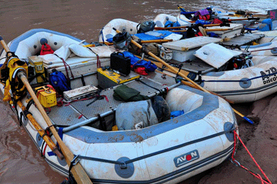
The track entered the creek bed just above the lower falls. I continued on a trail that bypassed the falls and descended to the creek bed at river level. This took just a few minutes and I immediately made a b-line for the lower falls where I washed away three days of sweat and trail dust, before eating lunch. It was a short trek from the falls to Stone Creek beach, where I selected a spot in the sand near the creek and started setting up camp for the night. An "Arizona Raft Adventures" party was setting up at the downstream end of the beach. John and Summer, two members of the crew, walked down to invite me to dinner, which would happen about 6:00 pm. I was pleased to accept.
The sound of the conch horn told me that dinner was ready at the AZRA camp. While I was organizing my camp, a second river party arrived at Stone Creek. This group was with "Oars." I met Monte, who I learned had grown up in Kanab and estimated having hiked 6,000 miles or more off the north rim of Grand Canyon. The AZRA dinner was wonderful. They served spaghetti with a sausage meat sauce, garlic bread, a garden salad with tomatoes, olives, cucumber and cheese, and freshly baked chocolate brownies for dessert. They even gave me a beer, a Pabst Blue Ribbon. They were a relatively small party with eight crew and an equal number of guests. As darkness began to fill the canyon and I was saying my goodnights, John and Summer extended an invitation to join them for breakfast. What could I say but, "You bet!" AZRA rocks!
The call of the conch roused me from sleep the next morning. Outside my tent, twilight had been growing for about thirty minutes. It was light enough that I didn't need the headlamp to find my clothes. While dressing, I noticed that portions of my sleeping bag were damp with dew. Since the weather had promised to be just about perfect the day before, I had not put the rain fly on my tent. So, before strolling down the beach for breakfast, I laid out my gear on a nearby rock to dry. Again the AZRA folks outdid themselves. Breakfast started with hot coffee and orange juice. The meal featured an omelet featuring the left over meat from last night's spaghetti dinner. The sides included slices of melon and English muffins with jam. This was so much better than I'm used to eating on a hike. When I do a river trip, I'm going with Arizona Raft Adventures.
After breaking camp, I followed Stone Creek upstream to the trail up past the lower falls to the upper creek bed. Once there, I removed my pack and left it in the shade to begin exploring up canyon. I brought my camera and a bottle of Gatorade. Stone Creek may be perennial. It had a good strong flow as far upstream as I hiked, with no indication of weakening. In addition to the Butchart and Steck notes, Dennis had also given me a copy of a hand-drawn map of the Stone Creek area. The map was made by George Beck in 1965. While I was interested in seeing the falls in upper Stone, what really motivated this short detour was the promise of finding ancestral Puebloan ruins. The Beck map indicated a ruins site just upstream of a landmark he had nicknamed the "Twin Chimneys."
The stone chimney's emerged about 30 minutes into the trek. This confirmation of Beck's map provided additional inspiration to keep going. At the Twin Chimneys landmark, the trail left the creek bed and climbed high along the eastern slopes. The trail allowed one to bypass a significant waterfall. Since the Beck map showed the ruins located between the chimneys and upper falls, I was a bit concerned that I had missed them. If this was the upper falls in his drawing, had I missed the ruins? Well, the best way to find out was to keep hiking and see for myself. So, onward I went and was rewarded for the effort. Not too far upstream from the falls, I spotted the remains of a granary to my left. The next half-hour was spent checking out and photographing the scene with my Nikon D90.
In addition to the small granary, I found a metate, some old sticks and a log that may, at some time in the distant past, have been part of a more complex constructed site. There were also small animal bones laying in the dust. That was a little creepy. Leaving the site, I made good time down Stone Creek and arrived back at my pack just a few minutes before 11:30 am. I soaked my Phantom Ranch neckerchief in the cool water of Stone Creek, wringing it out over my head and then tying the damp cloth around my neck. After applying some sunscreen, I was ready to go and left Stone Creek at 11:35 am on Saturday, October 9. This is a place I could see visiting again.
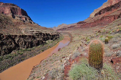
Despite wandering off the track in a few places, I made good time on the hike across the Tapeats bench. I don't know if it was the sun angle or if some other factor was at work, but I did find the route more difficult to discern on this day than the day prior. I also managed to lose track of the drainages. I stopped in one in the early afternoon because the south wall offered some nice shade. I decided to make this my lunch break and noted it as taking place in the unnamed drainage upstream of Hundred and Thirtythree Mile Canyon. After lunch while continuing the hike, it took about fifteen minutes before I realized my lunch break had been in Hundred and Thirtythree Mile. The next major drainage I was approaching was actually the mouth of Tapeats Creek.
At 1:20 pm, I rounded the mouth of Tapeats and began hiking up canyon. There was a raft tied off at the rocky mouth and I wondered if this was an AZRA raft. An Oars dory was tied off a bit further downstream from the creek mouth. Fifteen minutes of steady hiking brought me to the Tapeats Creek crossing. The first thing I did was use my collapsible bucket to scoop a couple of gallons of water from the creek and then pour the contents over my head. It was cool and refreshing. Later as I was getting ready to cross the creek, I spotted three people from the AZRA trip walking downstream along the west side trail. We exchanged, hellos, and they stopped to take a quick dip in Tapeats Creek. There was a natural water slide the spilled into a shallow area. It looked fun so, when I got to the other side, I decided to ride the chute. It took a minute or so to build up the courage to jump into the fast-flowing creek. But I did it! The current sucked me underwater at the chute but I popped back up after just a few seconds. It was fun!
The west side trail follows a bench that rises high above the lower Tapeats narrows. Just before reaching the mouth of Tapeats, the trail begins a switchbacking descent through a boulder-strewn break. The descent is nicely constructed and steep; steep but easy to follow. Those river runners know how to construct a trail. Twenty minutes after beginning the descent, I walked into the designated camping area. Tapeats is much different from Stone Creek. While Stone Creek is blessed with a football field long sandy beach, Tapeats delta is covered with boulders.
A father-son tandem showed up not long after my tent was up. They took a spot not too far from where I was setting up. Their names were Johann and Ben. While chatting and getting to know each other, I learned they were also headed to Deer Creek the next day. We would end up sharing campsites the last two nights of my trip. While filtering water for dinner by my tent, the father (Johann) got my attention and motioned toward something behind me. Turning, I spotted a big horn ram slowly making his way across the slope behind camp. He was no more than 100 feet from us and didn't appear to have a care in the world. What a magnificent creature!
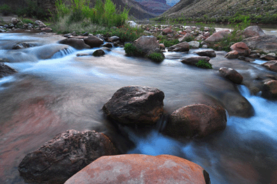
Later that night, I made a visit to Tapeats Creek to contribute to the volume. Scanning the shoreline with my headlamp, I spotted a pair of beady eyes, then a long body with a flat, round tale. It was a beaver and he appeared to be sleeping among the reeds. Eventually, he emerged from his slumber to realize he wasn't alone and scooted off to put some distance between himself and the human. I can almost imagine what must have been going through his mind. Back at the tent, I scanned some winter constellations with my binoculars, picking up the Orion Nebula (M42), the Flame Nebula (NGC 2024), the Pleiades (M45), the beautiful open star cluster, M35, in Gemini and Jupiter. To top off this observing session, a meteor streaked across the sky while I was reentering my tent.
The following day promised to be short and easy. My itinerary included a short 4 1/2 mile trek from Tapeats Creek to Deer Creek. The remainder of the day would be spent visiting Deer Creek falls and relaxing on the patio in the narrows. The route from the lower Tapeats campsite to Deer Creek is well-traveled and appropriately cairned. The ducks are there when you need them but not when you don't. The first 1 1/4 mile follows the boulder-strewn shore of the Colorado downstream. There is a steep but short bypass that goes up and over a chunk of schist. En route to Hundred and Thirtyfive Mile beach, I saw another great blue heron. This one was standing in the shallows of the Colorado. The route abandons river level at Hundred and Thirtyfive Mile beach. It is a short but steep climb. I worked up a good lather on that ascent.
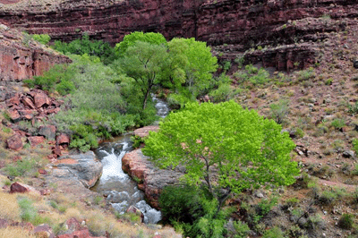
Once atop the ascent route from Hundred and Thirtyfive Mile, the trail follows Tapeats benches over a 1 1/2 mile distance to a saddle overlooking the verdant Deer Creek valley. The route passes through one major drainage below Cogswell Butte. It was not quite 10:00 am when I arrived at the saddle and beheld the lush Deer Creek riparian zone. It flows as a green ribbon across the floor of a wide valley. Cottonwoods abound and define the path Deer Creek follows to the river. The descent route led to a great place for making a crossing of Deer Creek. It was narrow and shallow so, I didn't even bother to put on my water shoes. After making the crossing, it was a short hike up the trail to the designated campsites. My camp was set up by 11:00 am.
After lunch, I made the trek down trail to see the one hundred foot water fall at the mouth of Deer Creek. Along the way, I met Johann and Ben. They were breaking for a snack, having just finished the hike from Tapeats Creek and arrived at creek crossing. I passed through a Tapeats bench patio immediately downstream from the crossing. Here, a group of guests from a river party were relaxing in the shade at the head of the Deer Creek narrows. The narrows quickly carve a deep gorge through the stone, having the effect of raising the trail to one hundred feet above the flowing, churning waters of the creek. The descent to river level follows a well-constructed stairway featuring stone steps spaced just right for people.
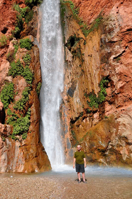
Deer Creek falls is simply awesome. It looks to be every inch of one hundred feet in height. The sound of the water hitting the pool is overwhelming. But the most amazing feature is the breeze created by the water impacting this pool. Wading through the hip-deep water, I worked to get as near as possible to the falls but could only approach to within about ten feet. Buffeted by a dense spray of water and a powerful gust of wind, I could get no closer. The gusting air and water spray made it difficult to breath. After one or two minutes in this maelstrom, I turned to walk out of the pool, soaked to the skin. For the second time on this hike, I had the rare privilege of feeling totally refreshed after a hard, hot day of hiking.
Several guests from two different river trips were assembled at the falls. Johann and Ben showed up, too. Each of us took turns getting our pictures taken next to the falls. After, each of us returned the favor by taking somebody else's photo. It was just a typical, cordial gathering of strangers on the Colorado River in Grand Canyon.
This was my last full day and night of the hike. The next day, October 11, would be devoted to the out. According to the map, I would gain about 5,500 feet in elevation, lose 900 feet of that along the way and cover nearly ten miles. That's the kind of day that works up a good sweat. Later in my tent, I estimated that a 1.5 mph pace would put me back in the Bill Hall trailhead parking area as early as 2:00 pm or, more reasonably, sometime between 3:00 pm and 4:00 pm. After that, my plan was to drive to the Jacob Lake Inn for a victory dinner.
I got an early start on the sixth day, leaving camp at 7:04 am. Most of the first hour on the trail was spent climbing out of Deer Creek Valley. The trail leaves the creek about 1/4 mile upstream from the campsites. It then follows a boulder field up to the cave spring where Deer Creek originates. The Throne Room made for an interesting diversion while in the area of the spring but only for a few minutes. Soon, I returned to the trail and followed its path through a boulder-choked drainage to the east. This would eventually lead to a more gradual slope along the western edge of Surprise Valley. There, I took a fifteen minute break to snack and replenish my electrolytes with some Gatorade.
Just before 9:00 am, I arrived at the junction with the Surprise Valley trail and the trail that would lead to the ascent route to the Esplanade. It was in the shade along the lower portion of that ascent that I took my second short break of the morning. Afterwards, I kept a steady pace along the ascent to the Esplanade, reaching that sandstone sea at 10:05 am. There, I retrieved my first water cache and mixed it with the last of my Gatorade powder. Rested and replenished, I set out across the Esplanade. It was about 11:30 am when I decided to stop for lunch at a large mushroom shaped rock. While the water pockets that had been filled to overflowing during my hike in the previous week were mostly dry, there were a couple of potholes, here, that caught abundant shade during the day. As a result, they still contained a portion of the rain water that had fallen nearly seven days before.
Resuming the trail, I reached the junction with Bill Hall trail at 12:26 pm. Not too far up the trail from there, I retrieved my second water cache. I drank half, and used the remainder to cool my head and neck. The last two ascents lay ahead. First, I tackled the Coconino, reaching a shaded spot in the Toroweap at a quarter past one. I finished the last of my trail mix during a fifteen minute break in an alcove atop the Coconino. Then, it was time to bring this hike to an end by finishing the last leg of the trip. The traverse of the Toroweap and final ascent through the Kaibab formation required a thirty-five minute push. At the end of that push, I arrived at the north rim. It was just after 2:00 pm and all that remained of the hike was the short downhill section to the parking area.
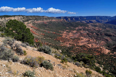
This was a great trip for so many reasons. The sheer abundance of water makes this loop hike a real treat. It is not often that one can spend six days in Grand Canyon without any concern over water--where to find it or when it will be found--but this is a hike that offers that luxury. If one plans and prepares properly for the Thunder River-Deer Creek loop, water should not be an issue. It is also a hike that offers a host of spectacular landscapes. Thunder River, Tapeats Creek, the Stone Creek falls, Deer Creek and its falls. All are A-list attractions. That these jewels are accessible via well-worn and appropriately marked trails makes the Thunder River-Deer Creek loop even more enjoyable. Route-finding is rarely an issue.
But for me, the most enjoyable aspect of this hike was that it offered almost no drama. There were no rock slides, no close encounters with tumbling stove-sized boulders and no air evacuations. It was just a walk in the park; a six-day and five-night walk in one of nature's most spectacular wonders, Grand Canyon National Park.
 |
 |
 |