
 |
 |
|
Swimming across the Colorado River was not part of the plan. Yet, there I was in the middle of the river and too damned far from either shore. No time to think. Just do. At least, I was in better shape than Dennis Foster's inflatable kayak. It was upside down in the water. If we lost the kayak, we'd be in deep yogurt, so I grabbed a handful of rope and hung on. Two unsuccessful attempts to right the craft later, I looked to my left and saw Dennis swimming toward the north side of the river. "OK," I said to myself, "that's where I'll go."
My backpack was trapped beneath the capsized kayak. This was a good thing as the pack would stay with me as long as it remained buoyant. With my left hand, I held fast to the rope at the bow of the craft. I kicked with my legs and stroked toward shore with my right arm. Between the life vest I was wearing and the kayak, I was in no immediate danger of going under. But dragging the kayak, my 45-lb. pack and the paddle that was tethered to my vest was hard work. The north shore didn't seem to be getting any closer. Then I noticed movement in the water behind me. Dennis' dry bag had come loose from the overturned inflatable and the current was carrying it quickly downstream. For the briefest of moments, I gave thought to going after the dry bag. But common sense prevailed. "Stay with the kayak!" I told myself.
My right arm was tiring from its solo effort through the current. So, I laid back and used just my legs to kick for the rocky shore. From this vantage point, it looked as though the cliff wall came straight down to the water. But a quick glance confirmed that Dennis had reached the north side and was out of the water on a shelf. "Why is he so far away? Am I getting anywhere?"
The water felt warmer than I'd expected, or at least not as cold as I recalled from the cautious wading in shallows I'd done on prior hikes. Despite my body's refusal to acknowledge the obvious, I knew the water was cold. In five or ten minutes at most, hypothermia would begin to set in. I kept kicking and started working with my right arm, again. Then I saw Dennis' backpack. Unbelievably, it was upstream of me. It must have been caught in a back eddy. In any event, the pack was now approaching on a downstream current. It looked close, close enough that I might be able to catch it. I started kicking and stroking with every ounce of energy I had. Closer. Almost there. Damn! The pack went silently past my outstretched arm. I'd missed it and still seemed no closer to shore.
That's when I started to feel the cold. My legs and arms were getting numb. Keeping the extremities warm in 50-degree water puts a lot of stress on the body. Eventually, it gives up the struggle and, in order to maintain warmth in the heart and brain, starts shutting down the heat supply to the arms and legs. I focused on kicking and swimming, blocked out the cold and the burning in my muscles. This was not the time to take a break.
And there it was. The north side of the river was noticeably closer. I'd broken through the back eddy and was making real progress toward shore. Almost instantaneously, the water depth went from some unknown darkness to just a few inches above a shallow rock shelf. But I didn't have the energy to climb up onto the shelf and maintain hold on the kayak. With perfect timing, Dennis extended his paddle toward me. I grabbed it and he pulled me in. Soon, I was on solid rock. I was soaked to the flesh, chilled to the bone and dead dog tired. But I was out of the water. I was back on land!
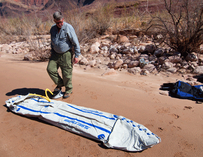
A river crossing had been part of our plan for this hike from the beginning. Both Dennis and I wanted to return to Chuar valley in eastern Grand Canyon. Hiking in from the North Rim would be iffy in March when snow could still be several feet deep. It would also require several days of hard hiking just to reach the valley. A river crossing would allow us to enter via the South Rim and would cut days from the entry and exit itineraries. We'd have more time to explore Lava and Chuar canyons. A river crossing also required greater planning and coordination. We had done an overnight hike down Tanner trail to the river on March 2-3 to cache Dennis' Sea Eagle inflatable kayak. It's a two-person craft and we cached it at Tanner wash near the river along with paddles, life vests, tents, food and other gear we'd need on the trip.
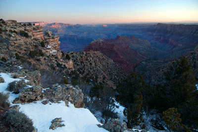
The following week on Friday, March 9, we returned to Lipan Point on the South Rim near Desert View to begin our nine-day, eight-night expedition. The day was warmer than the previous week and, although there was enough snow and ice in upper Tanner to require use of our Kahtoola's, I shed my jacket at Seventyfive Mile saddle. My sweater came off during a rest stop below the Redwall. With relatively light packs and our legs still being in canyon shape from the previous weekend, we reached Tanner wash in great shape at about 1:30 pm. Walking across the rocky debris field, we soon arrived at the cache.
We took our time prepping the kayak and our gear for the crossing. This was no time to rush, and miss a simple but critical step. The plan was to bring our gear over in two crossings. On the first, we would transport our packs, leaving them on the north side just downstream of the entrance to a narrow channel sheltered by an island. Then, we would return to the south side of the river for the balance of our gear. I sat in the bow with Dennis in the stern and our packs stacked between us. Dennis' dry bag was tucked away beneath the water skirt behind him. We launched from a narrow but sandy beach and were soon working our way across the current. About mid-stream, the combination of the main downstream current and an upstream back eddy grabbed and rolled the Sea Eagle.
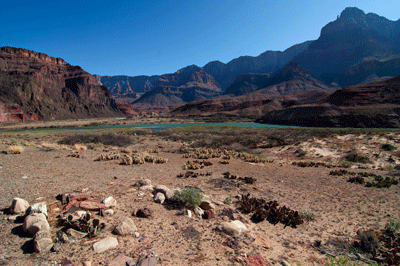
After getting out of the water onto the rock shelf along the north shore, I saw Dennis' backpack making another upstream run in the back eddy. The pack floated quickly past about 15 feet from shore. When it had traveled a short distance upstream, the pack drifted closer to shore where it entered a downstream current and started moving in our direction. Dennis grabbed his paddle, and was able to reach across the water and snag the pack, reeling it in. With both our packs securely on shore, we now had the bulk of our gear. Things were starting to look up.
Within minutes, the dry bag floated by on the same back eddy. It drifted into the same downstream current and scudded past too far from shore to reach with the paddle. Dennis took off on foot downstream in pursuit. While Dennis was off retrieving the dry bag, I started organizing the gear we had. First, I pulled the kayak from the water onto the rock shelf. Then, I started checking my pack for any missing gear, and also to determine the extent to which items were wet or dry. Amazingly, the only two items I lost were my hat and a plastic bag containing a map and pen from my right hip pants pocket. The pack contents were still secure and most of my food appeared to be dry. My clothes and sleeping bag were wet, and were soon laid out on the rocks exposed to the afternoon sun.
Dennis was gone longer than I'd expected and, when he did return with the dry bag, he was obviously shivering with cold. He'd had to jump back into the water--into the channel behind the island--to retrieve the dry bag. This second swim in the frigid Colorado had taken its toll. But we now had more of our gear and, just a few minutes later, another bit of good fortune floated our way in the form of a river trip. Several rafts came floating down the Colorado. Dennis hailed them and two rafts pulled in. Dennis told the trip leader that we had capsized but were OK. He explained that we still had gear on the Tanner wash side and would appreciate it if they could help with bringing it across. The trip leader agreed and, minutes later, he returned with the balance of our kit.
As the river party continued on their way, Dennis and I finally had time to collect ourselves and make a plan for the rest of the day. Just a quarter-mile downstream, the mouth of Basalt Canyon offered good campsites. And since several hours of daylight remained in the day, we decided to allow our gear to dry in the sun for another 30 minutes before packing up and moving on. We would use the time to warm up and catch our breath. The previous hour had been a bit unnerving but we had come through the ordeal about as well as could be expected. One of the kayak's inflatable seats was still missing. But, other than this and my hat, nothing of real consequence had been lost.
Forty-five minutes later with our packs and gear stowed in the Sea Eagle, we placed the kayak in the water, and used ropes at the bow and stern to line the craft downstream to the channel entrance. The current in the channel was pretty mellow and, with thick reeds along the shore making lining the kayak an near impossibility, we decided to get back on the proverbial horse. With Dennis sitting in the bow, me in the stern and Dennis' pack between us, we pushed off into the channel. We slowly made our way downstream using this calm stretch of water to regain our feel for navigating the Sea Eagle. A couple of minutes later, Dennis spotted a break in the reeds that looked promising as a place to access the shore. We pulled in, Dennis climbed out and secured the kayak to a tree. Dennis stayed with his pack while I paddled upstream to ferry my Osprey down to the landing. This return trip took but a few minutes.
After securely tying off the kayak to trees at the landing, Dennis and I hoisted our packs and made our way up slope to a slightly elevated terrace at the mouth of Basalt Canyon. Dennis had told me I would enjoy Basalt and, as we walked across the terrace, the reason for his enthusiasm became obvious. The ground was literally covered in pot sherds. Hundreds of broken pottery pieces covered an area half the size of a football field. They were everywhere. But as much as I wanted to drop everything and do some exploring, the day was getting late and we needed to make camp.
As we ate dinner that evening at Basalt, the last light of day painted the walls of Palisades of the Desert with brilliant shades of red, gold and ocher. After a day consumed by the constant attention to detail required to stay on schedule and overcome an unexpected challenge, it was nice to be able to relax and simply enjoy a sunset. Rather than pushing on to the Chuar Valley, we decided to remain at Basalt an extra day to allow our kit to dry and give ourselves an opportunity to rehearse the return trip. We would use the time to make a practice run in the Sea Eagle across the Colorado to Tanner wash. This was a crossing we would need to make in another five days as part of our exit from the canyon and it was clear that we needed the practice.
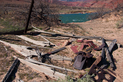
On day two, we slept in. It was 7:00 am when I finally crawled from my bag to begin the day. Dennis was still asleep, so I walked the neighborhood. The terrace at the mouth of Basalt Canyon is large, covering an area similar to half a football field. Pot sherds litter the ground, with even a few large pieces exposed. To the south of where we made camp, I found outlines and remnants of several ancient rooms. There were at least five by my count. After breakfast, Dennis and I explored the rest of the area. We crossed dry Basalt Creek and continued west between sand dunes to the other side of the delta where we found the remains of an old cabin. The cabin had long ago been home to miners working claims farther up Basalt Canyon. An old laundry stove still stands amongst the ruins.
Later that afternoon, we made a practice run in the kayak. We paddled upstream through the channel to a patch of sand near the channel's entrance. From there, we lined the Sea Eagle upstream to the spot where we'd first come ashore, the previous day. We found a natural slip where we could seat ourselves before pushing off. Entering the Colorado River proper, we made a few easy strokes with our paddles and broke through the back eddy, entering the main downstream flow. We eased off on the paddling and let the current take us where it wanted. Steering around a bend, we resumed paddling with easy strokes and gradually angled toward shore on river left. The water was more calm, here, and in less than a minute we pulled in at a beach near the best Tanner wash campsite.
We carried the Sea Eagle across rock and boulder strewn Tanner wash to the beach where we'd begun our crossing the day before. Shortly after arriving, we launched back into the Colorado and, again, allowed the downstream current to takes us. We paddled and steered toward the sandy east side of the island. After landing, we made a reconnaissance on foot along the island shore hoping to find my hat or the inflatable seat that had been lost. Finding neither, we returned to the kayak and paddled along the east shore to the channel entrance, deftly turned into the channel and brought the craft to shore.
Having completed a successful practice run, we cached the Sea Eagle, its paddles and our life vests beneath some rocks against the cliff wall. We marked the location with an old gate post and returned to camp on foot. It felt good to have gotten the practice run behind us. It was a good ride and we came away from the experience confident in our ability to navigate the river five days hence on our return crossing.
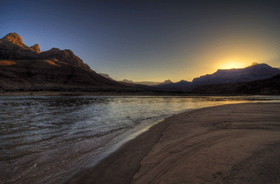
Photography is one of my motivations for backpacking in Grand Canyon. The opportunities to capture spectacular views are literally endless. For this trip, I had invested in a relatively lightweight Benro tripod. It weighs just over three pounds and collapses to about 18 inches in length. That's small enough to fit snugly in one of my pack's side pockets. I used the tripod daily for sunrise and sunset HDR sequences, and also to capture sequences of the more colorful and dramatic sights encountered during the day. The sunsets and sunrises from Basalt were truly amazing. On the evening of this second day, I set up on a gorgeous sandy beach to capture the sun setting over Vishnu Temple off to the west.
We broke camp and started hiking up Basalt Creek at about 8:00 am on the morning of the third day. This wasn't an early start but also not terribly late. The trek up lower Basalt offered some interesting opportunities for exploration and we took advantage of them. The most interesting find of the morning was an old mine above a waterfall. We bypassed the fall along the west (left) side and took a break in the shade of the canyon. While I snacked on trail mix, Dennis looked around and found copper ore on the east side of the creek. Near there, he also found metal posts, probably hauled in by the National Park Service to be used in barring a mine entrance. Following an old trail up the east side of the canyon wall, Dennis eventually found the mine. It was a small shaft, just barely large enough for a man and about ten feet deep. A wheelbarrow lay partially buried by the mouth of the dig, as if waiting for its next load of ore. Miscellaneous hardware was scattered about, giving the site an appearance of a hasty withdrawal by the last men to work this claim.
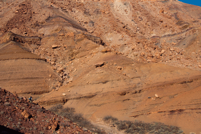
We found an easy walk-down route to the creek bed and resumed our trek. The goal for the day was to hike up Basalt Canyon to the Tapeats overlooking Chuar valley. There, we would find a break in the Tapeats, descend into the valley and follow a creek bed east to the Still Spring site in Lava Creek. This was to be an all-day adventure. Leaving narrow, shaded lower Basalt behind, we continued upstream through the creek bed. Above the last of the lower falls, Basalt Canyon opened up a bit and we got our first good view of the next obstacle to overcome. This came in the form of a boulder-choked drainage in a fascinating region of Grand Canyon with Super Group rock layers exposed as stacks of thin, colorful layers forming a beautiful composition.
We exited the creek bed to our left (west) to work our way up and northward across sloping hills below some rough looking cliffs. Below the spot where Basalt Creek merges with an upper plateau, we chose to descend into a ravine where a small grove of Cottonwood trees had made a home. The path was thick with vegetation of the carnivorous variety. Amongst the Cottonwoods, we found no sign of flowing water but there was shade, so we found some comfortable boulders and took a short lunch break. After eating, we continued across the boulder field to the north side of Basalt Creek where we ascended to the top of exposed Super Group layers angling westward to the top of the dry pour off. It was a grind but, once at the top, it was easy getting into the creek bed. From this point on, Basalt Creek is a relatively easy walk up to the north with a few minor bypasses of obstacles in the Tapeats narrows.
Arriving at the Tonto level, we were treated to a spectacular view of Chuar Valley. Off to the northeast (our right), Chuar Butte dominated the skyline. Galeros Butte, Gunther Castle, Butchart Butte and Siegfried Pyre were arranged, east-to-west, across this dramatic vista. What a magnificent scene! We found the historically-used break in the Tapeats and worked our way down the steeply sloping ramp. The descent took all of 15 minutes, after which we continued cross country until finding a route into the dry creek bed leading east to Lava Creek. We followed the creek bed and arrived at the Still Spring site at 6:00 pm, set up camp in the early evening twilight and ate dinner in the dark.
After the all-day trek from Basalt to Lava, we decided to keep day four relatively easy. The main objective for the day was to be a day hike down Lava Creek to the river. But before departing camp, we took time to explore the immediate area. Both of us had been to the Still Spring on previous trips but neither of us had ever found much evidence of past activity that had given the site its name. In 1928, a survey team led by Chief Ranger James Brooks explored northeastern Grand Canyon National Park. Their journey took them into Chuar Valley and Lava Creek. While exploring a Cottonwood grove along the west side of Lava, the group found an old trough, some bottles and kegs, two large barrels, a mash box, wooden paddle and a stone fireplace. Ranger Brown found an old coffee mill that had been spiked to a Cottonwood stump. What they had found was an abandoned moonshine operation.
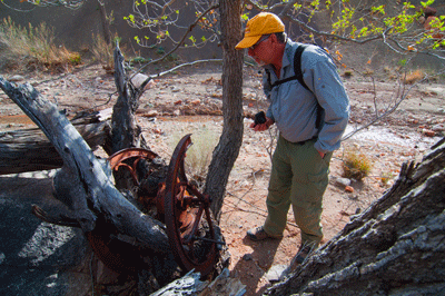
Looking around the area on the morning of the fourth day, Dennis found the remains of the water trough and fireplace. We also found some old barrel hoops and other hardware, but were stymied in our search for the coffee grinder. Then, while working my way back towards Lava Creek, I saw it. The grinder, an Elgin National coffee mill, was spiked to a Cottonwood stump along the west side of Lava Creek, just as described in the 1928 report. Over the years, the tree has grown around and engulfed the old mill. The front facing wheel is broken but "& Edwards Co.," is clearly legible on one side. On the inside of the other wheel, the first few letters of "Nation(al)" and "Cof(fee)" are visible. However, the elixir brewed at this site has long since disappeared.
At about 10:30 am, I started downstream for the river. Dennis would not be too far behind. There is something very relaxing about hiking beside clear, flowing water. Water is the essential resource in Grand Canyon. When you've got water in abundance, here, you're as wealthy as Bill Gates. While following the creek along its course, I enjoyed the little water falls, the interesting geology of the place and the developing view toward the mouth of Lava Creek. My first view of the Colorado River was with magnificent Palisades of the Desert as a backdrop. I found a trail on creek left that led to a boat beach upstream of the rapids. It was perfect, a soft sandy beach at the edge of a shallow sheltered bay where the mellow current invited a person to walk in and enjoy the cool flowing Colorado.
When Dennis arrived, we waded into the river to wash off a couple of days of trail dust. Afterwards, we ate lunch while reclining in the sand beneath a shade tree. This is Grand Canyon hiking at its best. We later moved to the downstream side of Lava, which also features a nice beach. While Dennis relaxed in the shade, I looked around for one of the old mines that once operated in this area. While I found an old trail and rebar site markers, the mine opening may have been filled in by the Park Service. From the vantage point of the ridge, there was a tremendous view of the river and the Palisades beach area on the other side. Two separate backpacker camps were set up across river. The trek back to camp was uneventful. We arrived at 5:00 pm and made an early dinner. The meal was awesome--lasagna followed by bananas Foster for dessert. Every bite was delicious.
Dennis and I took divergent paths the next day. While he returned to the Tapeats overlook in Basalt in search of evidence of the 1883 Walcott survey, I made the trek up Lava Creek to see Juno Ruin. I left camp just before 9:00 am to begin the three mile hike up Lava Creek. Along the way, there were three possible ruin sites I wanted to investigate, time allowing. Walking beside bubbling Lava Creek on this gorgeous, sunny morning, there was a spring in my step and an eagerness for what the day would bring. About a quarter mile upstream of where Lava bends to the west, an unnamed drainage merges from the north. Along the east side of this barren channel, a curling finger of a rise bends eastward. This is a place I had seen marked as a ruin site on other maps. I walked up the no-name channel in search of an access route to the top of the rise. Once there, I found a few pottery sherds and what looked to be the stone outlines of two rooms. From this rise, I could also see a lower plateau to the south. Walking down to the lower plateau, I found more pot sherds and outlines for five to seven additional rooms. In all, I spent about half an hour exploring this area.
Resuming the walk westward along Lava, I kept an eye open for the next possible ruin site. I'd marked this on my map as being half a mile west of the first site. This second candidate was indicated as being south and a skosh east of a hilltop marked as 4,245-feet in elevation. The actual ruin site was marked as south of Lava Creek on an elevated plateau. I spent 40 minutes exploring the best candidate site I could find. The search turned up a few pot sherds and some possible room outlines, but nothing as definitive as the first stop of the morning. Checking my watch, the day was fast approaching the Noon hour. If I wanted ample time for exploring Juno Ruin, I needed to put the peddle to the metal, so to speak.
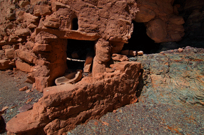
Ninety minutes of hot, hard hiking later, I arrived at the Juno Ruin site. Juno is spectacular, as well preserved a granary as I've seen in Grand Canyon. Before checking it out, I took a break to relax and eat lunch. Then, out came the camera and tripod. The granary at Juno remains about 3/4's complete and in excellent condition. In addition, the site features a smaller granary room, a metate stone, and petroglyphs and pictographs on the ceiling of the overhang. From this location, there is a great view to the south and the Redwall route to the Lava-Unkar saddle. After leaving Juno Ruin, I set a steady pace for the return trek and rolled into camp an hour and forty-five minutes later at 3:38 pm.
Back at camp, I took advantage of the late afternoon sun to do laundry and give myself a five-bucket shower. Lava flows cool and clear. When the wind would gust shortly after dousing myself with a bucket of Lava water, the effect was quite bracing.
It made a huge difference that we had hiked the Basalt-to-Lava route just a few days prior to our return hike over the same course. On his day hike, Dennis had returned to the Tapeats to explore an alternate route. His reconnaissance confirmed that overland to the Tapeats break we'd used would be the fastest way out of Chuar Valley. We broke camp at 9:00 am and left the Still Spring for the last time. We'd had an enjoyable two-days and three-nights in Lava. I wish it could've been longer.
Following an old trail up from the creek, we soon reached the elevated plateau and set course overland for the Tapeats break. We reached the top of the Tapeats at 11:15 am, found a one-liter water cache Dennis had left the previous day and settled down beneath a Juniper tree for an early lunch break. Afterwards, we headed down a shallow crease in the Tonto. The crease became a minor ravine, the ravine a drainage and eventually we dropped into Basalt Canyon. Just after 2:00 pm, we arrived at the boulder-choked pour off that had proven so interesting a few days prior. Foregoing the steep Super Group ramp descent, we chose to negotiate a boulder field along the south (right) side of Basalt. This led to a dense scrub and tree grove that took some careful work to negotiate. But we got through and took a break in the shade of a large block of stone. The time was shortly after 2:30 pm.
It took a bit less than an hour to hike down slope to the creek bed, walk to the first of the lower falls and lower our packs. From this point on, the hike was smooth sailing. We arrived at our camp site at the mouth of Basalt a tad shy of 5:00 pm and went about the business of settling in for the night.
Day seven would be critical for us. This was the day we needed to ferry our gear and ourselves across the Colorado to Tanner wash. Two crossings would be needed and, given the success of our practice run the previous week, we approached the day with high confidence. We didn't need to travel far but we did need to travel well. Knowing the day's agenda was fairly light, we slept in and took our time breaking camp. It was more important to make sure our packs were rigged for wet than to get an early, fast start to the day.
At 9:15 am, we left Basalt camp for the final time on this trip and made the short hike to the spot where we'd cached the kayak. We found everything just as it had been left. After continuing upstream along the rock shelves to deposit our packs at the launch point, we returned downstream to inflate the kayak and prep for the first crossing. As we'd done on the practice run, we lined the fully-inflated Sea Eagle upstream along the north shore to our launch point. The dry bag was tucked into the open compartment at the stern. Dennis' pack was laid flat in the middle with the kayak pack on top. The packs and dry bag were tied off to the kayak to keep them with the craft in the event of another dunking. I climbed in at the stern with my legs resting on the pontoons astride the packs. Dennis sat in the bow and we pushed off.
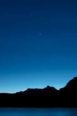
Backing stern first into the river, I pivoted the craft to aim the bow into the current pointing slightly downstream. We stroked easily through the back eddy and entered the strongest downstream current. Last week during the practice run, we had let the current carry us around the bend, coming ashore near the Tanner wash camp site. On this crossing, a couple of strong strokes with our paddles pushed us through the main current and into a somewhat weaker flow. A few more strokes gave me the confidence that we could continue straight across to the south shore, before rounding the point. I aimed the bow slightly upstream, and both Dennis and I gave several solid strokes with the paddles. Soon after, the bow of the Sea Eagle slid onto the Tanner wash beach. We were ashore.
It didn't take long to unload the kayak and be ready for the return trip to the north side. As we had done last week, we pushed off the sandy beach and I pivoted the kayak to point bow-first downstream. We let the current carry us toward the island and then aimed for a point along the east shore near the entrance to the channel. Once near the island, I redirected the craft to head upstream for the entrance. We turned left into the sheltered channel and were soon pulling into the natural, little boat slip. One last time, we lined the kayak upstream along the north shore of the Colorado. We loaded my pack and pushed off into the main current. This time, we let the current take us around the bend. After rounding the point of Tanner wash, we gradually angled into the calm water along the shore. I didn't want us to carry too much momentum into the landing and dragged my paddle to slow the kayak. For the final time, we felt the front of the Sea Eagle gliding across sand while coming to a stop.
Success! We'd done it. The crossings were complete and all the work that remained on this day was to set up camp. Later that afternoon, I made the short trek west along the Escalante Route to visit the purported site of Felix Lantier's old mine. Speculation about Lantier and his various mining operations in the Canyon has been around for decades with little in the way of solid evidence to support a particular site as having been run by the man. Harvey Butchart marked a location along the Colorado River opposite the mouth of Basalt as one possible site. The Escalante Route goes directly to this bend in the river where countless tons of trash and debris have been delivered over the decades by flood waters. I found an old, rusted piece of hardware, but neither an exploratory dig nor the dismantled cabin remains Butchart photographed.
The next two days would be dedicated to the chore of packing out all our gear. The pack list included Dennis' inflatable kayak. The Sea Eagle had been central to the success--and adventure--of the previous seven days. But now, it would function merely as dead weight; a 50-lb. pack hitching a ride out on our backs. We adopted a plan for sharing this burden. One of us would start the day shuttling his pack and the kayak pack up trail. Meanwhile, the other would make good time to our planned destination. Once there, he would drop his pack and return down trail to meet the shuttler, take possession of the kayak and haul it the rest of the way. On day eight, I had the pleasure of shuttling the Sea Eagle in the morning.
We left our camp on Tanner wash at 8:25 am, following a nearby drainage away from the river to a point where we could connect with the Tanner trail. It was 9:05 am when we arrived at the Tanner trail at a spot near the 3080-foot contour. I set down the kayak pack by a tree, munched a couple of handfuls of trail mix, drank some Gatorade and turned to head back to the Tanner wash camp where my pack would (hopefully) be waiting. Returning to camp some 20 minutes later, I strapped on my Osprey Aether 70 and scanned the site for any forgotten items. Satisfied we'd left no more evidence of our stay than footprints, I set boot to trail to leave Tanner wash one last time. The Osprey was a good ten pounds lighter than the kayak pack and, more importantly, carried much better. The kayak pack always seemed to be tugging at my shoulders. No matter the adjustments I made, it never felt comfortable; never felt right.
As I approached the place where the Sea Eagle had been left, two ravens were standing patiently along the trail as if plotting how they were going to get to the kayak pack. Dennis had left it beneath tree and shrub branches, which seemed enough of a discouragement to prevent the ravens from causing too much mischief. I didn't want to leave anything to chance where my Osprey was concerned. Before leaving to carry the kayak farther up trail, I spent about 15 minutes gathering more branches to thicken the protective layer surrounding my pack. Only when I was confident a covey of ravens would be stymied in any attempt to get at the Osprey, did I load up the Sea Eagle and start up trail. The time was now 10:45 am.
The day before had turned out to be fairly warm at the river. Dennis and I had estimated the high temperature in the vicinity of 90-degrees. This day was shaping up to be warm, as well. The weight of the kayak pack and the discomfort of how it carried combined to leave me exhausted and overheating by the time I stopped for a rest in the Tapeats. The spot I chose is one Dennis and I have dubbed, World's Smallest Cairn. Don't ask me why; it's an inside joke. In any event, it is a spot along Tanner in the Tapeats that would make a nice camp in a pinch. I would estimate it being at the 3,800-foot contour. Although there were no ravens hanging around, my previous experience had instilled a level of caution that led me to conceal the kayak under a pile of rocks. This was hot, heavy work in the growing warmth of the day. I left the pack at 11:40 am to retrace my boot steps and retrieve my pack.
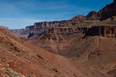
I looked at my watch. I'd just strapped on the Osprey and was ready to head up trail to World's Smallest Cairn (WSM) and the time was 12:05 pm. Ugh. I'd been hiking for 3 1/2 hours and was still just 30 minutes from last night's camp. Even more than the physical effort the pack shuttling had required, the mental strain of repeatedly walking the same short stretch of trail is what took the greatest toll on me that morning. By the time I arrived at WSM, I could feel the effects of heat exhaustion starting to creep over me. There was effectively no shade at this spot. But the last meal I'd had was breakfast some five hours before. I needed a break and I needed to eat. So, I wedged myself between the largest boulders I could find and ate my lunch.
About the time I was finishing my sandwich, I heard my friend's voice, "Hey, Bill!" It was Dennis. He'd made it to the Redwall and had returned to retrieve the Sea Eagle. I was hot, dehydrated and not in a good mood. He'd not eaten and was just settling in for his lunch break when I announced, "I need shade," and hoisted my pack to resume hiking. This caught Dennis a bit off guard but he understood. The nearest reliable shelter from the sun was a spot in the Muav we'd nicknamed Slim Shady. (Another inside joke.) It was a good 30-to-45 minute hike from World's Smallest Cairn with a full pack. I wanted to get there as soon as possible, so with a wave of my hand, I headed out.
The rest of the day went better for me than the morning had. I arrived at Slim Shady just after 2:00 pm, removed my pack and immediately lay down on the ground. I didn't move from that position for the next half hour. The cool of the shade and cool of the rocks worked together to lower my core body temperature. After my rest, Gatorade and snacks were actually appetizing. This was a good sign as it meant my progression towards heat exhaustion had been arrested. When Dennis arrived, I was starting to feel like my old self. We stayed another 10 minutes or so in the comforting cool before heading out to continue up through the Muav to the base of the Redwall. It was probably 2:45 pm when we left Slim Shady. An hour and fifteen minutes later, I was atop the Redwall looking to retrieve a food and water cache we'd placed the previous week.
As the afternoon progressed toward evening, gusting winds buffeted our Redwall campsite. The weather change turned out to be a harbinger of a strong winter storm that was approaching northern Arizona. We'd gotten word of the storm from a couple of hikers we met during the day. Listening to the wind whipslap my tent's rain fly, I was hoping the storm wouldn't arrive a day early. The prospect of hiking out in a raging snow storm was not appealing.
I needn't have worried. The ninth and last day of our trip went swimmingly. (Pun intended.) The day was sunny, a bit windy but with comfortable temperatures. Despite Tanner being snow and ice covered through the Kaibab formation, I still felt comfortable hiking in a long sleeve shirt with my sweater and jacket stowed in my pack. Dennis was on shuttle duty for the morning. A surprisingly restful night and the opportunity to photograph an amazingly beautiful sunrise had left me feeling stronger and more chipper about the day to come. I was also looking forward to getting home, hugging my wife and son, eating a really good meal and sleeping on a soft mattress. This was going to be a great day.
Hiking up through the Coconino and Toroweap, I encountered several groups of backpackers. Each encounter provided an excuse to stop and chat, to enjoy the company of others. On days two through seven, we had not encountered another soul. On day eight, we'd met some hikers on Tanner, but I was in no mood to be sociable. Now, I was craving human companionship. I wanted to engage in conversation and socialize with others. These chance meetings were fun.
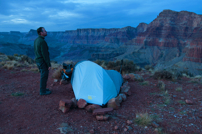
I arrived at the Isuzu Rodeo in Lipan Point parking lot at 12:30 pm. After stowing my pack, snacking and drinking some Gatorade, I was ready to head back down Tanner. I made good time along the trail, descending the Kaibab in my Kahtoola's, removing them before the Coconino steps and finally meeting Dennis in the Hermit shale. It had taken me 45 minutes to reach him and I figured the return trek up the same section of trail would take about twice that time. Ninety minutes of hauling the Sea Eagle up Tanner trail wasn't terribly appealing but it needed to be done. I squared my shoulders and took the approach of hiking for 15 minutes and resting for five. In this manner, I slowly but steadily made progress toward the rim. Eventually, I even caught up to Dennis. Together, we finished the hike by walking past the trailhead sign onto Lipan Point Road at just before 3:00 pm.
This turned out to be one of the most adventurous and enjoyable Grand Canyon hikes I've done. Our misadventure on the first river crossing concluded as a trial by fire that we passed with flying colors. We rebounded from that experience to complete the nine-day trek in fine fashion. Along the way, we experienced the rich history of the human presence in Grand Canyon in the form of ancient ruins and old mining claims. We enjoyed fine backcountry hiking, were treated to spectacular views and my new tripod allowed me to do the best photography of my six-years hiking Grand Canyon. Tanner-Basalt-Lava was a great trip, the kind of trip that leaves one asking, "Where to, next?"
 |
 |
 |